|
|
|||||||||||||||||
| Point ID: 6883 | Downloads | Plots | Site Data | Code: 10511 |
|
|
|||||||||||||||||
| Download | |
|---|---|
| Site Descriptor Information | Site Time Series Data |
| Link to all available data | |
| View: | Time Series | All |
| Units: | mm |
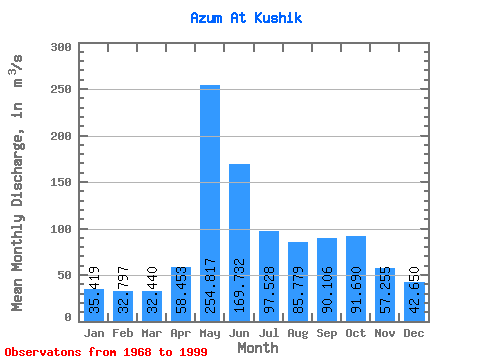
| Statistic | Jan | Feb | Mar | Apr | May | Jun | Jul | Aug | Sep | Oct | Nov | Dec | Annual |
|---|---|---|---|---|---|---|---|---|---|---|---|---|---|
| Mean | 35.42 | 32.80 | 32.44 | 58.45 | 254.82 | 169.73 | 97.53 | 85.78 | 90.11 | 91.69 | 57.26 | 42.65 | 86.91 |
| Standard Deviation | 6.22 | 4.85 | 4.70 | 44.44 | 90.81 | 54.74 | 38.88 | 58.31 | 41.01 | 50.75 | 19.65 | 10.89 | 18.84 |
| Min | 23.60 | 23.40 | 20.90 | 23.10 | 98.50 | 87.30 | 49.30 | 41.40 | 37.30 | 35.20 | 31.60 | 21.90 | 61.99 |
| Max | 48.70 | 43.80 | 41.70 | 212.00 | 447.00 | 292.00 | 190.00 | 337.00 | 214.00 | 255.00 | 108.00 | 71.40 | 141.43 |
| Coefficient of Variation | 0.18 | 0.15 | 0.14 | 0.76 | 0.36 | 0.32 | 0.40 | 0.68 | 0.46 | 0.55 | 0.34 | 0.26 | 0.22 |
 Return to R-Arctic Net Home Page