|
|
|||||||||||||||||
| Point ID: 6882 | Downloads | Plots | Site Data | Code: 10509 |
|
|
|||||||||||||||||
| Download | |
|---|---|
| Site Descriptor Information | Site Time Series Data |
| Link to all available data | |
| View: | Time Series | All |
| Units: | mm |
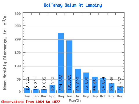
| Statistic | Jan | Feb | Mar | Apr | May | Jun | Jul | Aug | Sep | Oct | Nov | Dec | Annual |
|---|---|---|---|---|---|---|---|---|---|---|---|---|---|
| Mean | 18.91 | 15.21 | 13.01 | 30.94 | 224.69 | 195.32 | 89.82 | 75.80 | 59.43 | 54.86 | 36.04 | 24.46 | 69.45 |
| Standard Deviation | 6.35 | 4.16 | 3.03 | 19.05 | 89.02 | 94.18 | 55.41 | 43.72 | 34.13 | 33.83 | 16.85 | 8.89 | 20.53 |
| Min | 10.90 | 8.64 | 7.05 | 8.94 | 100.00 | 50.40 | 35.90 | 23.30 | 20.50 | 19.20 | 13.90 | 15.20 | 38.57 |
| Max | 30.00 | 21.30 | 16.90 | 70.00 | 365.00 | 379.00 | 232.00 | 162.00 | 124.00 | 144.00 | 72.80 | 46.80 | 98.94 |
| Coefficient of Variation | 0.34 | 0.27 | 0.23 | 0.62 | 0.40 | 0.48 | 0.62 | 0.58 | 0.57 | 0.62 | 0.47 | 0.36 | 0.30 |
 Return to R-Arctic Net Home Page