|
|
|||||||||||||||||
| Point ID: 6874 | Downloads | Plots | Site Data | Code: 10500 |
|
|
|||||||||||||||||
| Download | |
|---|---|
| Site Descriptor Information | Site Time Series Data |
| Link to all available data | |
| View: | Time Series | All |
| Units: | mm |
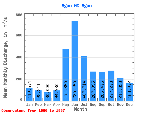
| Statistic | Jan | Feb | Mar | Apr | May | Jun | Jul | Aug | Sep | Oct | Nov | Dec | Annual |
|---|---|---|---|---|---|---|---|---|---|---|---|---|---|
| Mean | 119.57 | 95.31 | 80.00 | 94.93 | 474.85 | 730.45 | 407.71 | 267.10 | 266.48 | 277.28 | 211.83 | 163.97 | 274.65 |
| Standard Deviation | 46.14 | 28.36 | 15.72 | 26.20 | 181.36 | 217.67 | 170.79 | 115.04 | 123.16 | 134.65 | 97.92 | 78.06 | 61.35 |
| Min | 66.50 | 52.40 | 49.40 | 48.50 | 125.00 | 336.00 | 222.00 | 142.00 | 141.00 | 137.00 | 108.00 | 86.30 | 193.97 |
| Max | 272.00 | 163.00 | 111.00 | 166.00 | 822.00 | 1060.00 | 785.00 | 517.00 | 588.00 | 598.00 | 526.00 | 433.00 | 389.89 |
| Coefficient of Variation | 0.39 | 0.30 | 0.20 | 0.28 | 0.38 | 0.30 | 0.42 | 0.43 | 0.46 | 0.49 | 0.46 | 0.48 | 0.22 |
 Return to R-Arctic Net Home Page