|
|
|||||||||||||||||
| Point ID: 6862 | Downloads | Plots | Site Data | Code: 10480 |
|
|
|||||||||||||||||
| Download | |
|---|---|
| Site Descriptor Information | Site Time Series Data |
| Link to all available data | |
| View: | Time Series | All |
| Units: | mm |
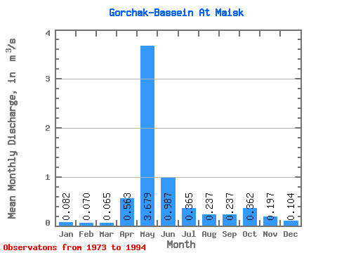
| Statistic | Jan | Feb | Mar | Apr | May | Jun | Jul | Aug | Sep | Oct | Nov | Dec | Annual |
|---|---|---|---|---|---|---|---|---|---|---|---|---|---|
| Mean | 0.08 | 0.07 | 0.07 | 0.56 | 3.68 | 0.99 | 0.36 | 0.24 | 0.24 | 0.36 | 0.20 | 0.10 | 0.57 |
| Standard Deviation | 0.03 | 0.02 | 0.02 | 0.42 | 2.89 | 0.69 | 0.45 | 0.31 | 0.21 | 0.37 | 0.22 | 0.06 | 0.34 |
| Min | 0.04 | 0.04 | 0.04 | 0.07 | 0.69 | 0.10 | 0.06 | 0.05 | 0.05 | 0.05 | 0.04 | 0.05 | 0.15 |
| Max | 0.17 | 0.11 | 0.10 | 1.73 | 10.40 | 2.18 | 1.72 | 1.42 | 0.79 | 1.33 | 1.05 | 0.26 | 1.23 |
| Coefficient of Variation | 0.40 | 0.28 | 0.25 | 0.74 | 0.79 | 0.70 | 1.24 | 1.30 | 0.87 | 1.02 | 1.12 | 0.53 | 0.59 |
 Return to R-Arctic Net Home Page