|
|
|||||||||||||||||
| Point ID: 686 | Downloads | Plots | Site Data | Code: 07CA006 |
|
|
|||||||||||||||||
| Download | |
|---|---|
| Site Descriptor Information | Site Time Series Data |
| Link to all available data | |
| View: | Time Series | All |
| Units: | mm |
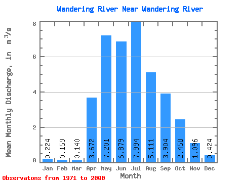
| Statistic | Jan | Feb | Mar | Apr | May | Jun | Jul | Aug | Sep | Oct | Nov | Dec | Annual |
|---|---|---|---|---|---|---|---|---|---|---|---|---|---|
| Mean | 0.22 | 0.16 | 0.14 | 3.67 | 7.20 | 6.88 | 7.99 | 5.11 | 3.90 | 2.46 | 1.10 | 0.42 | 3.21 |
| Standard Deviation | 0.16 | 0.09 | 0.06 | 4.01 | 6.39 | 7.14 | 7.53 | 7.25 | 5.71 | 3.21 | 1.06 | 0.34 | 2.06 |
| Min | 0.00 | 0.00 | 0.04 | 0.29 | 0.41 | 0.49 | 0.13 | 0.01 | 0.00 | 0.00 | 0.00 | 0.00 | 0.49 |
| Max | 0.85 | 0.48 | 0.35 | 18.60 | 26.50 | 27.90 | 29.10 | 37.20 | 24.70 | 13.10 | 4.34 | 1.46 | 9.09 |
| Coefficient of Variation | 0.72 | 0.57 | 0.46 | 1.09 | 0.89 | 1.04 | 0.94 | 1.42 | 1.46 | 1.30 | 0.96 | 0.81 | 0.64 |
 Return to R-Arctic Net Home Page