|
|
|||||||||||||||||
| Point ID: 6844 | Downloads | Plots | Site Data | Code: 10440 |
|
|
|||||||||||||||||
| Download | |
|---|---|
| Site Descriptor Information | Site Time Series Data |
| Link to all available data | |
| View: | Time Series | All |
| Units: | mm |
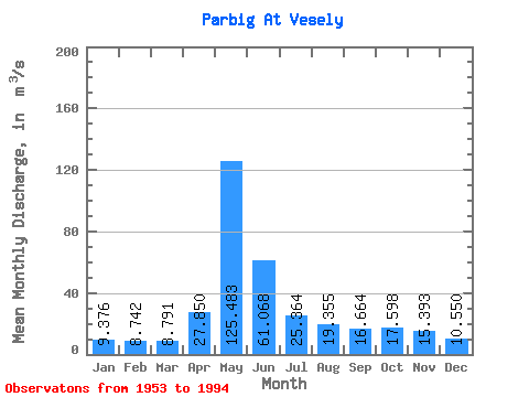
| Statistic | Jan | Feb | Mar | Apr | May | Jun | Jul | Aug | Sep | Oct | Nov | Dec | Annual |
|---|---|---|---|---|---|---|---|---|---|---|---|---|---|
| Mean | 9.38 | 8.74 | 8.79 | 27.85 | 125.48 | 61.07 | 25.36 | 19.36 | 16.66 | 17.60 | 15.39 | 10.55 | 28.85 |
| Standard Deviation | 1.77 | 1.43 | 1.35 | 20.34 | 75.18 | 45.04 | 23.15 | 15.72 | 10.15 | 8.93 | 6.82 | 2.58 | 13.41 |
| Min | 6.73 | 5.83 | 6.40 | 8.94 | 16.90 | 11.60 | 8.23 | 6.26 | 5.03 | 6.52 | 7.79 | 6.54 | 10.21 |
| Max | 14.60 | 12.10 | 12.40 | 107.00 | 332.00 | 208.00 | 140.00 | 87.20 | 64.70 | 48.20 | 35.40 | 17.70 | 77.48 |
| Coefficient of Variation | 0.19 | 0.16 | 0.15 | 0.73 | 0.60 | 0.74 | 0.91 | 0.81 | 0.61 | 0.51 | 0.44 | 0.24 | 0.47 |
 Return to R-Arctic Net Home Page