|
|
|||||||||||||||||
| Point ID: 6839 | Downloads | Plots | Site Data | Code: 10430 |
|
|
|||||||||||||||||
| Download | |
|---|---|
| Site Descriptor Information | Site Time Series Data |
| Link to all available data | |
| View: | Time Series | All |
| Units: | mm |
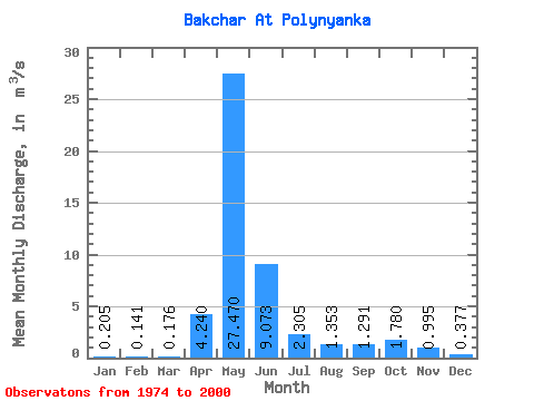
| Statistic | Jan | Feb | Mar | Apr | May | Jun | Jul | Aug | Sep | Oct | Nov | Dec | Annual |
|---|---|---|---|---|---|---|---|---|---|---|---|---|---|
| Mean | 0.20 | 0.14 | 0.18 | 4.24 | 27.47 | 9.07 | 2.31 | 1.35 | 1.29 | 1.78 | 0.99 | 0.38 | 4.12 |
| Standard Deviation | 0.20 | 0.14 | 0.20 | 3.20 | 21.86 | 8.96 | 3.46 | 1.63 | 1.77 | 2.01 | 1.31 | 0.42 | 2.96 |
| Min | 0.04 | 0.03 | 0.01 | 0.18 | 4.75 | 0.46 | 0.11 | 0.05 | 0.05 | 0.11 | 0.10 | 0.06 | 1.03 |
| Max | 0.87 | 0.65 | 0.96 | 10.10 | 71.70 | 37.40 | 12.90 | 6.65 | 5.95 | 7.19 | 4.72 | 1.78 | 12.53 |
| Coefficient of Variation | 0.97 | 0.97 | 1.12 | 0.76 | 0.80 | 0.99 | 1.50 | 1.20 | 1.37 | 1.13 | 1.31 | 1.11 | 0.72 |
 Return to R-Arctic Net Home Page