|
|
|||||||||||||||||
| Point ID: 6817 | Downloads | Plots | Site Data | Other Close Sites | Code: 10388 |
|
|
|||||||||||||||||
| Download | |
|---|---|
| Site Descriptor Information | Site Time Series Data |
| Link to all available data | |
| View: | Time Series | All |
| Units: | mm |
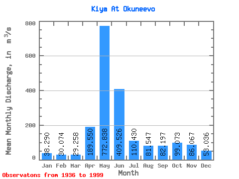
| Statistic | Jan | Feb | Mar | Apr | May | Jun | Jul | Aug | Sep | Oct | Nov | Dec | Annual |
|---|---|---|---|---|---|---|---|---|---|---|---|---|---|
| Mean | 38.29 | 30.07 | 29.26 | 189.55 | 772.84 | 409.53 | 110.43 | 81.55 | 82.20 | 99.07 | 86.07 | 53.04 | 166.76 |
| Standard Deviation | 13.21 | 7.63 | 8.34 | 102.09 | 155.33 | 203.34 | 43.29 | 33.09 | 36.10 | 40.80 | 37.28 | 19.73 | 28.93 |
| Min | 23.60 | 14.40 | 9.75 | 32.20 | 418.00 | 85.00 | 40.50 | 27.10 | 23.10 | 16.00 | 34.90 | 30.90 | 122.29 |
| Max | 85.20 | 51.60 | 57.70 | 501.00 | 1120.00 | 861.00 | 233.00 | 189.00 | 180.00 | 175.00 | 175.00 | 126.00 | 247.23 |
| Coefficient of Variation | 0.34 | 0.25 | 0.28 | 0.54 | 0.20 | 0.50 | 0.39 | 0.41 | 0.44 | 0.41 | 0.43 | 0.37 | 0.17 |
| Other Close Sites | ||||||
|---|---|---|---|---|---|---|
| PointID | Latitude | Longitude | Drainage Area | Source | Name | |
| 6792 | "Chulym At Zyryanskoye" | 56.85 | -214315 | SHI | 373.00 | |
 Return to R-Arctic Net Home Page