|
|
|||||||||||||||||
| Point ID: 6814 | Downloads | Plots | Site Data | Code: 10384 |
|
|
|||||||||||||||||
| Download | |
|---|---|
| Site Descriptor Information | Site Time Series Data |
| Link to all available data | |
| View: | Time Series | All |
| Units: | mm |
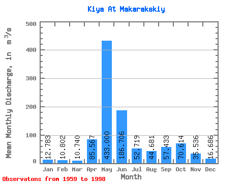
| Statistic | Jan | Feb | Mar | Apr | May | Jun | Jul | Aug | Sep | Oct | Nov | Dec | Annual |
|---|---|---|---|---|---|---|---|---|---|---|---|---|---|
| Mean | 12.78 | 10.80 | 10.74 | 85.57 | 433.00 | 186.71 | 52.72 | 44.68 | 57.43 | 70.61 | 35.54 | 16.69 | 84.77 |
| Standard Deviation | 3.84 | 2.95 | 2.59 | 50.14 | 91.63 | 100.28 | 24.41 | 19.48 | 28.87 | 27.85 | 20.59 | 7.42 | 13.44 |
| Min | 5.96 | 5.35 | 5.81 | 15.70 | 210.00 | 48.40 | 21.80 | 16.00 | 16.80 | 20.00 | 12.90 | 7.41 | 59.84 |
| Max | 20.90 | 18.30 | 16.40 | 199.00 | 639.00 | 411.00 | 129.00 | 101.00 | 109.00 | 141.00 | 106.00 | 47.00 | 111.83 |
| Coefficient of Variation | 0.30 | 0.27 | 0.24 | 0.59 | 0.21 | 0.54 | 0.46 | 0.44 | 0.50 | 0.39 | 0.58 | 0.45 | 0.16 |
 Return to R-Arctic Net Home Page