|
|
|||||||||||||||||
| Point ID: 6804 | Downloads | Plots | Site Data | Code: 10361 |
|
|
|||||||||||||||||
| Download | |
|---|---|
| Site Descriptor Information | Site Time Series Data |
| Link to all available data | |
| View: | Time Series | All |
| Units: | mm |
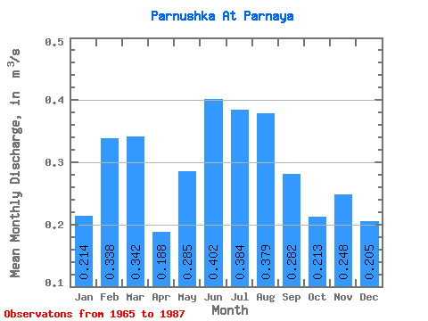
| Statistic | Jan | Feb | Mar | Apr | May | Jun | Jul | Aug | Sep | Oct | Nov | Dec | Annual |
|---|---|---|---|---|---|---|---|---|---|---|---|---|---|
| Mean | 0.21 | 0.34 | 0.34 | 0.19 | 0.28 | 0.40 | 0.38 | 0.38 | 0.28 | 0.21 | 0.25 | 0.20 | 0.30 |
| Standard Deviation | 0.27 | 0.27 | 0.24 | 0.34 | 0.43 | 0.46 | 0.51 | 0.56 | 0.34 | 0.23 | 0.24 | 0.29 | 0.28 |
| Min | 0.01 | 0.20 | 0.19 | 0.00 | 0.01 | 0.01 | 0.00 | 0.01 | 0.03 | 0.01 | 0.00 | 0.00 | 0.15 |
| Max | 1.06 | 0.98 | 0.90 | 1.33 | 1.97 | 1.74 | 2.25 | 2.62 | 1.34 | 0.87 | 0.93 | 1.28 | 0.87 |
| Coefficient of Variation | 1.25 | 0.79 | 0.70 | 1.79 | 1.52 | 1.14 | 1.32 | 1.47 | 1.20 | 1.07 | 0.98 | 1.44 | 0.95 |
 Return to R-Arctic Net Home Page