|
|
|||||||||||||||||
| Point ID: 6787 | Downloads | Plots | Site Data | Code: 10310 |
|
|
|||||||||||||||||
| Download | |
|---|---|
| Site Descriptor Information | Site Time Series Data |
| Link to all available data | |
| View: | Time Series | All |
| Units: | mm |
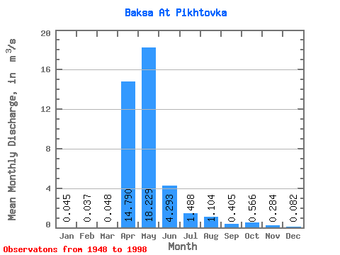
| Statistic | Jan | Feb | Mar | Apr | May | Jun | Jul | Aug | Sep | Oct | Nov | Dec | Annual |
|---|---|---|---|---|---|---|---|---|---|---|---|---|---|
| Mean | 0.04 | 0.04 | 0.05 | 14.79 | 18.23 | 4.29 | 1.49 | 1.10 | 0.41 | 0.57 | 0.28 | 0.08 | 3.57 |
| Standard Deviation | 0.10 | 0.08 | 0.09 | 18.91 | 16.42 | 4.77 | 2.48 | 2.57 | 0.73 | 1.05 | 0.52 | 0.20 | 2.57 |
| Min | 0.00 | 0.00 | 0.00 | 0.15 | 0.19 | 0.07 | 0.01 | 0.00 | 0.00 | 0.00 | 0.00 | 0.00 | 0.39 |
| Max | 0.44 | 0.37 | 0.44 | 102.00 | 58.30 | 20.80 | 14.50 | 13.20 | 3.40 | 4.86 | 2.37 | 0.93 | 10.05 |
| Coefficient of Variation | 2.21 | 2.15 | 1.95 | 1.28 | 0.90 | 1.11 | 1.67 | 2.33 | 1.80 | 1.85 | 1.83 | 2.43 | 0.72 |
 Return to R-Arctic Net Home Page