|
|
|||||||||||||||||
| Point ID: 6785 | Downloads | Plots | Site Data | Code: 10306 |
|
|
|||||||||||||||||
| Download | |
|---|---|
| Site Descriptor Information | Site Time Series Data |
| Link to all available data | |
| View: | Time Series | All |
| Units: | mm |
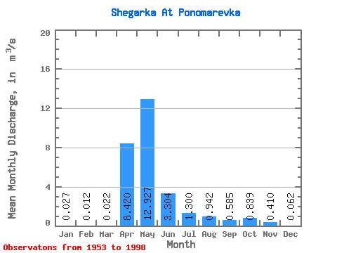
| Statistic | Jan | Feb | Mar | Apr | May | Jun | Jul | Aug | Sep | Oct | Nov | Dec | Annual |
|---|---|---|---|---|---|---|---|---|---|---|---|---|---|
| Mean | 0.03 | 0.01 | 0.02 | 8.42 | 12.93 | 3.30 | 1.30 | 0.94 | 0.58 | 0.84 | 0.41 | 0.06 | 2.75 |
| Standard Deviation | 0.06 | 0.03 | 0.04 | 9.19 | 11.25 | 3.79 | 2.69 | 1.74 | 1.03 | 1.20 | 0.64 | 0.12 | 1.88 |
| Min | 0.00 | 0.00 | 0.00 | 0.02 | 0.09 | 0.00 | 0.00 | 0.00 | 0.00 | 0.00 | 0.00 | 0.00 | 0.40 |
| Max | 0.24 | 0.10 | 0.12 | 46.70 | 44.50 | 15.30 | 14.70 | 6.48 | 3.87 | 4.28 | 2.90 | 0.47 | 6.64 |
| Coefficient of Variation | 2.17 | 2.07 | 1.63 | 1.09 | 0.87 | 1.15 | 2.07 | 1.85 | 1.76 | 1.43 | 1.56 | 1.87 | 0.68 |
 Return to R-Arctic Net Home Page