|
|
|||||||||||||||||
| Point ID: 6780 | Downloads | Plots | Site Data | Code: 10295 |
|
|
|||||||||||||||||
| Download | |
|---|---|
| Site Descriptor Information | Site Time Series Data |
| Link to all available data | |
| View: | Time Series | All |
| Units: | mm |
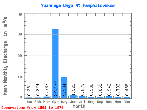
| Statistic | Jan | Feb | Mar | Apr | May | Jun | Jul | Aug | Sep | Oct | Nov | Dec | Annual |
|---|---|---|---|---|---|---|---|---|---|---|---|---|---|
| Mean | 0.38 | 0.32 | 0.79 | 32.48 | 9.93 | 1.52 | 0.88 | 0.59 | 0.67 | 0.94 | 0.70 | 0.44 | 4.15 |
| Standard Deviation | 0.20 | 0.17 | 1.15 | 8.07 | 12.25 | 0.87 | 0.58 | 0.26 | 0.33 | 0.50 | 0.56 | 0.27 | 1.36 |
| Min | 0.16 | 0.14 | 0.21 | 24.70 | 1.62 | 0.21 | 0.34 | 0.26 | 0.36 | 0.55 | 0.31 | 0.15 | 2.70 |
| Max | 0.79 | 0.70 | 4.50 | 50.30 | 49.60 | 3.55 | 2.39 | 1.07 | 1.70 | 2.18 | 2.28 | 1.09 | 7.54 |
| Coefficient of Variation | 0.53 | 0.51 | 1.46 | 0.25 | 1.23 | 0.57 | 0.66 | 0.43 | 0.49 | 0.53 | 0.79 | 0.61 | 0.33 |
 Return to R-Arctic Net Home Page