|
|
|||||||||||||||||
| Point ID: 6761 | Downloads | Plots | Site Data | Code: 10246 |
|
|
|||||||||||||||||
| Download | |
|---|---|
| Site Descriptor Information | Site Time Series Data |
| Link to all available data | |
| View: | Time Series | All |
| Units: | mm |
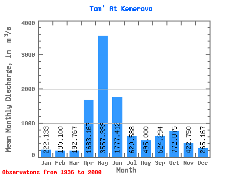
| Statistic | Jan | Feb | Mar | Apr | May | Jun | Jul | Aug | Sep | Oct | Nov | Dec | Annual |
|---|---|---|---|---|---|---|---|---|---|---|---|---|---|
| Mean | 222.13 | 190.10 | 192.77 | 1683.17 | 3557.33 | 1777.41 | 620.59 | 495.00 | 624.29 | 772.88 | 422.75 | 265.17 | 834.24 |
| Standard Deviation | 68.31 | 62.20 | 74.36 | 938.93 | 1030.01 | 1100.66 | 384.70 | 276.64 | 289.80 | 446.00 | 148.99 | 64.44 | 192.83 |
| Min | 72.60 | 74.20 | 97.20 | 608.00 | 1060.00 | 718.00 | 287.00 | 188.00 | 248.00 | 361.00 | 222.00 | 177.00 | 403.17 |
| Max | 331.00 | 281.00 | 366.00 | 4130.00 | 5270.00 | 4740.00 | 1650.00 | 978.00 | 1200.00 | 1930.00 | 702.00 | 352.00 | 1194.92 |
| Coefficient of Variation | 0.31 | 0.33 | 0.39 | 0.56 | 0.29 | 0.62 | 0.62 | 0.56 | 0.46 | 0.58 | 0.35 | 0.24 | 0.23 |
 Return to R-Arctic Net Home Page