|
|
|||||||||||||||||
| Point ID: 6747 | Downloads | Plots | Site Data | Code: 10211 |
|
|
|||||||||||||||||
| Download | |
|---|---|
| Site Descriptor Information | Site Time Series Data |
| Link to all available data | |
| View: | Time Series | All |
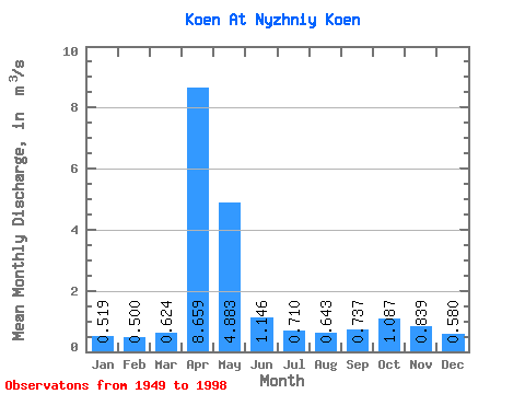
| Units: | mm |
| Statistic | Jan | Feb | Mar | Apr | May | Jun | Jul | Aug | Sep | Oct | Nov | Dec | Annual |
|---|---|---|---|---|---|---|---|---|---|---|---|---|---|
| Mean | 0.52 | 0.50 | 0.62 | 8.66 | 4.88 | 1.15 | 0.71 | 0.64 | 0.74 | 1.09 | 0.84 | 0.58 | 1.73 |
| Standard Deviation | 0.23 | 0.21 | 0.35 | 3.56 | 3.22 | 0.50 | 0.43 | 0.43 | 0.42 | 0.45 | 0.40 | 0.25 | 0.45 |
| Min | 0.04 | 0.18 | 0.13 | 2.50 | 1.40 | 0.36 | 0.13 | 0.14 | 0.20 | 0.46 | 0.32 | 0.03 | 0.92 |
| Max | 0.93 | 1.00 | 1.86 | 20.40 | 13.20 | 2.56 | 2.17 | 2.63 | 2.27 | 2.14 | 2.21 | 1.05 | 2.80 |
| Coefficient of Variation | 0.44 | 0.42 | 0.57 | 0.41 | 0.66 | 0.44 | 0.61 | 0.68 | 0.57 | 0.41 | 0.48 | 0.44 | 0.26 |
 Return to R-Arctic Net Home Page