|
|
|||||||||||||||||
| Point ID: 6745 | Downloads | Plots | Site Data | Code: 10209 |
|
|
|||||||||||||||||
| Download | |
|---|---|
| Site Descriptor Information | Site Time Series Data |
| Link to all available data | |
| View: | Time Series | All |
| Units: | mm |
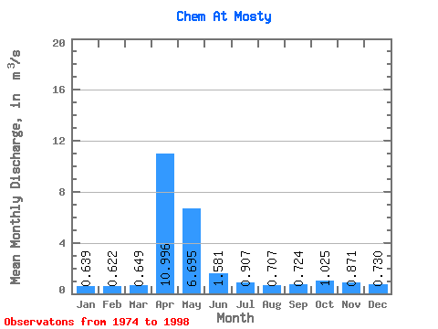
| Statistic | Jan | Feb | Mar | Apr | May | Jun | Jul | Aug | Sep | Oct | Nov | Dec | Annual |
|---|---|---|---|---|---|---|---|---|---|---|---|---|---|
| Mean | 0.64 | 0.62 | 0.65 | 11.00 | 6.70 | 1.58 | 0.91 | 0.71 | 0.72 | 1.02 | 0.87 | 0.73 | 2.19 |
| Standard Deviation | 0.32 | 0.33 | 0.33 | 4.81 | 4.50 | 0.72 | 0.51 | 0.32 | 0.40 | 0.54 | 0.38 | 0.31 | 0.51 |
| Min | 0.19 | 0.23 | 0.22 | 2.88 | 1.89 | 0.49 | 0.24 | 0.23 | 0.22 | 0.32 | 0.29 | 0.12 | 1.33 |
| Max | 1.46 | 1.57 | 1.62 | 22.20 | 18.10 | 3.09 | 2.44 | 1.62 | 1.70 | 2.53 | 1.80 | 1.23 | 2.98 |
| Coefficient of Variation | 0.50 | 0.53 | 0.50 | 0.44 | 0.67 | 0.45 | 0.56 | 0.46 | 0.55 | 0.53 | 0.43 | 0.42 | 0.23 |
 Return to R-Arctic Net Home Page