|
|
|||||||||||||||||
| Point ID: 6739 | Downloads | Plots | Site Data | Code: 10196 |
|
|
|||||||||||||||||
| Download | |
|---|---|
| Site Descriptor Information | Site Time Series Data |
| Link to all available data | |
| View: | Time Series | All |
| Units: | mm |
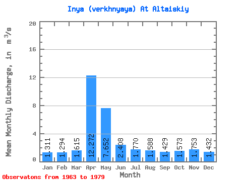
| Statistic | Jan | Feb | Mar | Apr | May | Jun | Jul | Aug | Sep | Oct | Nov | Dec | Annual |
|---|---|---|---|---|---|---|---|---|---|---|---|---|---|
| Mean | 1.31 | 1.29 | 1.61 | 12.27 | 7.65 | 2.41 | 1.77 | 1.59 | 1.43 | 1.57 | 1.75 | 1.43 | 2.99 |
| Standard Deviation | 0.43 | 0.31 | 0.90 | 5.15 | 4.41 | 0.63 | 0.41 | 0.29 | 0.19 | 0.25 | 0.65 | 0.33 | 0.52 |
| Min | 0.10 | 0.83 | 0.84 | 2.65 | 2.81 | 1.75 | 1.30 | 1.19 | 1.12 | 1.23 | 1.21 | 1.09 | 2.16 |
| Max | 1.92 | 1.75 | 4.66 | 21.60 | 16.50 | 3.98 | 2.82 | 2.19 | 1.72 | 1.96 | 3.83 | 2.36 | 3.95 |
| Coefficient of Variation | 0.33 | 0.24 | 0.56 | 0.42 | 0.58 | 0.26 | 0.23 | 0.18 | 0.14 | 0.16 | 0.37 | 0.23 | 0.17 |
 Return to R-Arctic Net Home Page