|
|
|||||||||||||||||
| Point ID: 6737 | Downloads | Plots | Site Data | Code: 10193 |
|
|
|||||||||||||||||
| Download | |
|---|---|
| Site Descriptor Information | Site Time Series Data |
| Link to all available data | |
| View: | Time Series | All |
| Units: | mm |
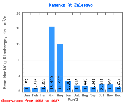
| Statistic | Jan | Feb | Mar | Apr | May | Jun | Jul | Aug | Sep | Oct | Nov | Dec | Annual |
|---|---|---|---|---|---|---|---|---|---|---|---|---|---|
| Mean | 1.16 | 1.07 | 1.35 | 16.40 | 11.97 | 2.86 | 1.62 | 1.45 | 1.34 | 2.01 | 1.90 | 1.26 | 3.70 |
| Standard Deviation | 0.42 | 0.36 | 0.91 | 6.73 | 8.28 | 1.66 | 0.95 | 0.89 | 0.76 | 0.82 | 0.95 | 0.50 | 0.93 |
| Min | 0.47 | 0.43 | 0.53 | 5.45 | 3.13 | 1.18 | 0.67 | 0.56 | 0.54 | 0.93 | 0.84 | 0.46 | 2.25 |
| Max | 2.13 | 1.84 | 5.85 | 31.60 | 33.50 | 7.11 | 4.99 | 4.12 | 4.19 | 3.56 | 4.85 | 2.27 | 5.66 |
| Coefficient of Variation | 0.36 | 0.34 | 0.68 | 0.41 | 0.69 | 0.58 | 0.59 | 0.62 | 0.56 | 0.41 | 0.50 | 0.40 | 0.25 |
 Return to R-Arctic Net Home Page