|
|
|||||||||||||||||
| Point ID: 6736 | Downloads | Plots | Site Data | Code: 10189 |
|
|
|||||||||||||||||
| Download | |
|---|---|
| Site Descriptor Information | Site Time Series Data |
| Link to all available data | |
| View: | Time Series | All |
| Units: | mm |
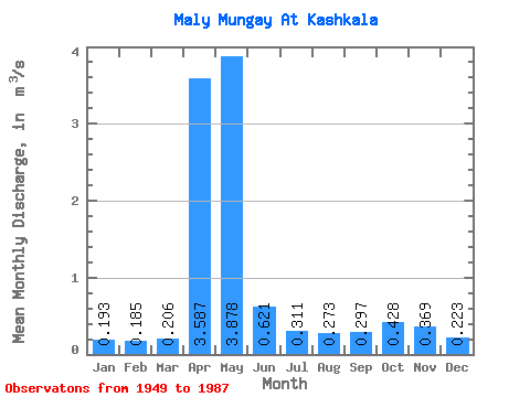
| Statistic | Jan | Feb | Mar | Apr | May | Jun | Jul | Aug | Sep | Oct | Nov | Dec | Annual |
|---|---|---|---|---|---|---|---|---|---|---|---|---|---|
| Mean | 0.19 | 0.18 | 0.21 | 3.59 | 3.88 | 0.62 | 0.31 | 0.27 | 0.30 | 0.43 | 0.37 | 0.22 | 0.89 |
| Standard Deviation | 0.07 | 0.07 | 0.08 | 2.04 | 2.62 | 0.44 | 0.20 | 0.14 | 0.15 | 0.22 | 0.31 | 0.07 | 0.23 |
| Min | 0.07 | 0.06 | 0.07 | 0.43 | 0.64 | 0.15 | 0.13 | 0.07 | 0.10 | 0.15 | 0.09 | 0.08 | 0.53 |
| Max | 0.37 | 0.37 | 0.40 | 8.71 | 11.70 | 1.85 | 1.28 | 0.72 | 0.67 | 1.26 | 2.04 | 0.39 | 1.50 |
| Coefficient of Variation | 0.38 | 0.37 | 0.38 | 0.57 | 0.68 | 0.71 | 0.63 | 0.51 | 0.49 | 0.52 | 0.84 | 0.34 | 0.26 |
 Return to R-Arctic Net Home Page