|
|
|||||||||||||||||
| Point ID: 6704 | Downloads | Plots | Site Data | Code: 10113 |
|
|
|||||||||||||||||
| Download | |
|---|---|
| Site Descriptor Information | Site Time Series Data |
| Link to all available data | |
| View: | Time Series | All |
| Units: | mm |
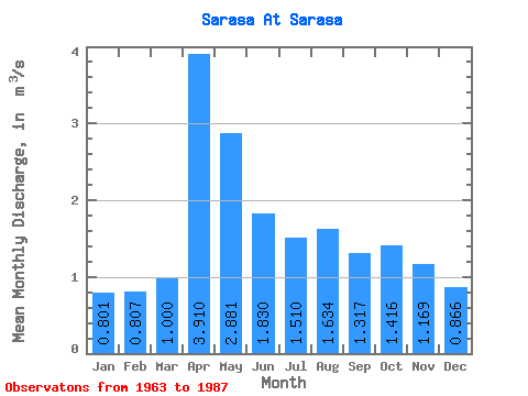
| Statistic | Jan | Feb | Mar | Apr | May | Jun | Jul | Aug | Sep | Oct | Nov | Dec | Annual |
|---|---|---|---|---|---|---|---|---|---|---|---|---|---|
| Mean | 0.80 | 0.81 | 1.00 | 3.91 | 2.88 | 1.83 | 1.51 | 1.63 | 1.32 | 1.42 | 1.17 | 0.87 | 1.61 |
| Standard Deviation | 0.28 | 0.34 | 0.28 | 1.17 | 1.60 | 0.73 | 0.73 | 0.97 | 0.45 | 0.52 | 0.33 | 0.27 | 0.41 |
| Min | 0.41 | 0.19 | 0.53 | 1.55 | 0.77 | 0.64 | 0.64 | 0.84 | 0.79 | 0.68 | 0.78 | 0.44 | 0.89 |
| Max | 1.68 | 1.60 | 1.71 | 5.51 | 7.08 | 3.56 | 4.25 | 5.03 | 2.38 | 2.52 | 2.05 | 1.83 | 2.44 |
| Coefficient of Variation | 0.35 | 0.41 | 0.28 | 0.30 | 0.56 | 0.40 | 0.48 | 0.59 | 0.34 | 0.37 | 0.28 | 0.31 | 0.25 |
 Return to R-Arctic Net Home Page