|
|
|||||||||||||||||
| Point ID: 6702 | Downloads | Plots | Site Data | Code: 10111 |
|
|
|||||||||||||||||
| Download | |
|---|---|
| Site Descriptor Information | Site Time Series Data |
| Link to all available data | |
| View: | Time Series | All |
| Units: | mm |
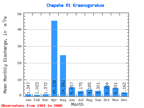
| Statistic | Jan | Feb | Mar | Apr | May | Jun | Jul | Aug | Sep | Oct | Nov | Dec | Annual |
|---|---|---|---|---|---|---|---|---|---|---|---|---|---|
| Mean | 1.35 | 1.02 | 1.37 | 45.24 | 24.56 | 5.46 | 3.17 | 4.18 | 3.30 | 6.27 | 5.03 | 2.16 | 8.59 |
| Standard Deviation | 0.67 | 0.52 | 1.21 | 10.59 | 16.81 | 2.94 | 2.67 | 6.00 | 3.08 | 4.94 | 3.73 | 1.28 | 1.94 |
| Min | 0.27 | 0.11 | 0.39 | 28.20 | 6.37 | 1.50 | 0.80 | 0.84 | 0.79 | 1.16 | 1.25 | 0.60 | 5.45 |
| Max | 3.20 | 2.58 | 6.62 | 64.70 | 84.40 | 11.50 | 15.40 | 26.90 | 12.40 | 19.80 | 15.60 | 6.86 | 14.10 |
| Coefficient of Variation | 0.49 | 0.51 | 0.88 | 0.23 | 0.68 | 0.54 | 0.84 | 1.43 | 0.93 | 0.79 | 0.74 | 0.59 | 0.23 |
 Return to R-Arctic Net Home Page