|
|
|||||||||||||||||
| Point ID: 67 | Downloads | Plots | Site Data | Code: 05AC017 |
|
|
|||||||||||||||||
| Download | |
|---|---|
| Site Descriptor Information | Site Time Series Data |
| Link to all available data | |
| View: | Time Series | All |
| Units: | mm |
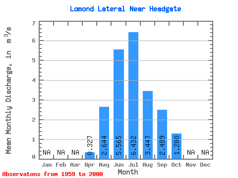
| Statistic | Jan | Feb | Mar | Apr | May | Jun | Jul | Aug | Sep | Oct | Nov | Dec | Annual |
|---|---|---|---|---|---|---|---|---|---|---|---|---|---|
| Mean | 0.33 | 2.64 | 5.56 | 6.43 | 3.45 | 2.49 | 1.28 | ||||||
| Standard Deviation | 0.74 | 2.79 | 3.33 | 3.90 | 1.77 | 1.92 | 0.69 | ||||||
| Min | 0.00 | 0.00 | 0.47 | 0.88 | 0.77 | 0.36 | 0.13 | ||||||
| Max | 2.56 | 9.81 | 12.70 | 13.40 | 6.62 | 7.87 | 3.27 | ||||||
| Coefficient of Variation | 2.26 | 1.06 | 0.60 | 0.61 | 0.52 | 0.77 | 0.54 |
 Return to R-Arctic Net Home Page