|
|
|||||||||||||||||
| Point ID: 6680 | Downloads | Plots | Site Data | Code: 10063 |
|
|
|||||||||||||||||
| Download | |
|---|---|
| Site Descriptor Information | Site Time Series Data |
| Link to all available data | |
| View: | Time Series | All |
| Units: | mm |
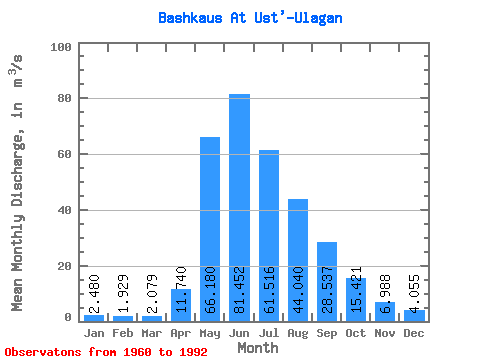
| Statistic | Jan | Feb | Mar | Apr | May | Jun | Jul | Aug | Sep | Oct | Nov | Dec | Annual |
|---|---|---|---|---|---|---|---|---|---|---|---|---|---|
| Mean | 2.48 | 1.93 | 2.08 | 11.74 | 66.18 | 81.45 | 61.52 | 44.04 | 28.54 | 15.42 | 6.99 | 4.05 | 27.15 |
| Standard Deviation | 1.07 | 1.09 | 0.90 | 6.22 | 18.27 | 38.17 | 25.05 | 23.06 | 11.25 | 4.96 | 3.08 | 1.84 | 7.87 |
| Min | 0.71 | 0.48 | 0.65 | 1.89 | 41.50 | 35.90 | 21.10 | 14.20 | 11.20 | 6.76 | 2.70 | 1.22 | 16.80 |
| Max | 4.33 | 4.63 | 4.10 | 29.80 | 120.00 | 204.00 | 137.00 | 122.00 | 68.90 | 26.40 | 15.40 | 8.19 | 43.05 |
| Coefficient of Variation | 0.43 | 0.57 | 0.43 | 0.53 | 0.28 | 0.47 | 0.41 | 0.52 | 0.39 | 0.32 | 0.44 | 0.45 | 0.29 |
 Return to R-Arctic Net Home Page