|
|
|||||||||||||||||
| Point ID: 6655 | Downloads | Plots | Site Data | Code: 9544 |
|
|
|||||||||||||||||
| Download | |
|---|---|
| Site Descriptor Information | Site Time Series Data |
| Link to all available data | |
| View: | Time Series | All |
| Units: | mm |
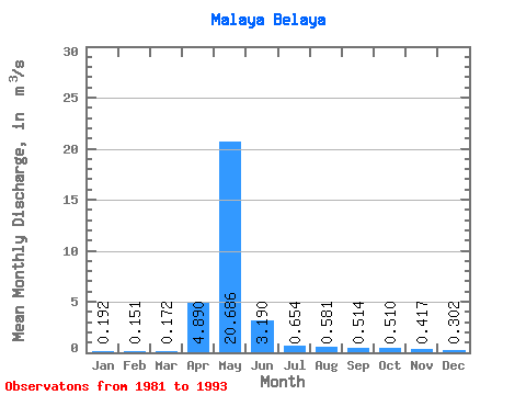
| Statistic | Jan | Feb | Mar | Apr | May | Jun | Jul | Aug | Sep | Oct | Nov | Dec | Annual |
|---|---|---|---|---|---|---|---|---|---|---|---|---|---|
| Mean | 0.19 | 0.15 | 0.17 | 4.89 | 20.69 | 3.19 | 0.65 | 0.58 | 0.51 | 0.51 | 0.42 | 0.30 | 2.69 |
| Standard Deviation | 0.07 | 0.06 | 0.09 | 7.27 | 8.47 | 2.00 | 0.16 | 0.19 | 0.12 | 0.08 | 0.10 | 0.10 | 0.46 |
| Min | 0.13 | 0.08 | 0.03 | 0.09 | 9.00 | 1.44 | 0.48 | 0.43 | 0.32 | 0.39 | 0.28 | 0.15 | 2.00 |
| Max | 0.32 | 0.26 | 0.33 | 18.30 | 34.80 | 7.48 | 0.95 | 1.09 | 0.72 | 0.62 | 0.60 | 0.48 | 3.48 |
| Coefficient of Variation | 0.35 | 0.37 | 0.54 | 1.49 | 0.41 | 0.63 | 0.24 | 0.33 | 0.24 | 0.16 | 0.23 | 0.33 | 0.17 |
 Return to R-Arctic Net Home Page