|
|
|||||||||||||||||
| Point ID: 665 | Downloads | Plots | Site Data | Code: 07BF002 |
|
|
|||||||||||||||||
| Download | |
|---|---|
| Site Descriptor Information | Site Time Series Data |
| Link to all available data | |
| View: | Time Series | All |
| Units: | mm |
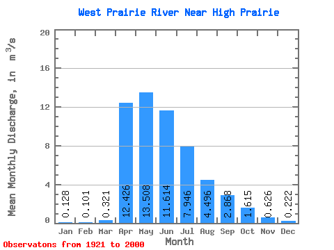
| Statistic | Jan | Feb | Mar | Apr | May | Jun | Jul | Aug | Sep | Oct | Nov | Dec | Annual |
|---|---|---|---|---|---|---|---|---|---|---|---|---|---|
| Mean | 0.13 | 0.10 | 0.32 | 12.43 | 13.51 | 11.61 | 7.95 | 4.50 | 2.87 | 1.61 | 0.63 | 0.22 | 4.77 |
| Standard Deviation | 0.11 | 0.10 | 0.34 | 10.57 | 8.59 | 12.45 | 8.24 | 7.38 | 3.71 | 1.84 | 0.45 | 0.18 | 2.79 |
| Min | 0.00 | 0.00 | 0.00 | 0.34 | 2.07 | 1.00 | 0.12 | 0.07 | 0.02 | 0.02 | 0.01 | 0.02 | 1.16 |
| Max | 0.41 | 0.42 | 1.51 | 40.90 | 35.00 | 63.60 | 34.60 | 34.60 | 18.60 | 8.22 | 1.59 | 0.72 | 12.63 |
| Coefficient of Variation | 0.85 | 1.02 | 1.06 | 0.85 | 0.64 | 1.07 | 1.04 | 1.64 | 1.29 | 1.14 | 0.71 | 0.82 | 0.58 |
 Return to R-Arctic Net Home Page