|
|
|||||||||||||||||
| Point ID: 664 | Downloads | Plots | Site Data | Code: 07BF001 |
|
|
|||||||||||||||||
| Download | |
|---|---|
| Site Descriptor Information | Site Time Series Data |
| Link to all available data | |
| View: | Time Series | All |
| Units: | mm |
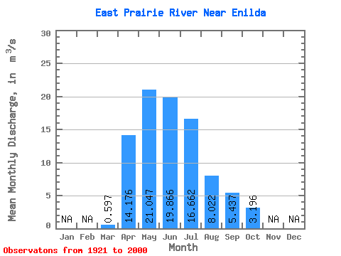
| Statistic | Jan | Feb | Mar | Apr | May | Jun | Jul | Aug | Sep | Oct | Nov | Dec | Annual |
|---|---|---|---|---|---|---|---|---|---|---|---|---|---|
| Mean | 0.60 | 14.18 | 21.05 | 19.87 | 16.66 | 8.02 | 5.44 | 3.20 | |||||
| Standard Deviation | 0.73 | 11.03 | 11.75 | 19.83 | 16.22 | 9.10 | 4.48 | 2.35 | |||||
| Min | 0.01 | 1.40 | 3.69 | 2.09 | 0.63 | 0.64 | 0.46 | 0.56 | |||||
| Max | 4.71 | 52.60 | 51.70 | 100.00 | 79.50 | 42.40 | 16.20 | 11.40 | |||||
| Coefficient of Variation | 1.23 | 0.78 | 0.56 | 1.00 | 0.97 | 1.13 | 0.82 | 0.73 |
 Return to R-Arctic Net Home Page