|
|
|||||||||||||||||
| Point ID: 6618 | Downloads | Plots | Site Data | Code: 9394 |
|
|
|||||||||||||||||
| Download | |
|---|---|
| Site Descriptor Information | Site Time Series Data |
| Link to all available data | |
| View: | Time Series | All |
| Units: | mm |
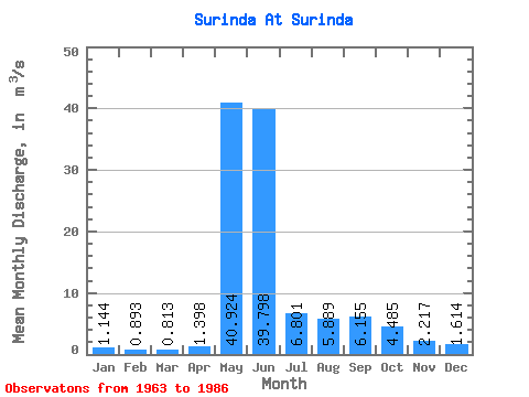
| Statistic | Jan | Feb | Mar | Apr | May | Jun | Jul | Aug | Sep | Oct | Nov | Dec | Annual |
|---|---|---|---|---|---|---|---|---|---|---|---|---|---|
| Mean | 1.14 | 0.89 | 0.81 | 1.40 | 40.92 | 39.80 | 6.80 | 5.89 | 6.16 | 4.49 | 2.22 | 1.61 | 9.79 |
| Standard Deviation | 0.83 | 0.60 | 0.47 | 1.38 | 16.93 | 26.95 | 4.74 | 5.91 | 5.67 | 4.36 | 1.49 | 1.04 | 2.96 |
| Min | 0.18 | 0.08 | 0.00 | 0.00 | 7.17 | 9.33 | 2.07 | 1.52 | 1.04 | 0.72 | 0.62 | 0.47 | 7.01 |
| Max | 3.46 | 2.31 | 1.55 | 5.70 | 65.80 | 107.00 | 18.70 | 26.00 | 23.30 | 15.80 | 6.29 | 5.03 | 15.83 |
| Coefficient of Variation | 0.73 | 0.67 | 0.57 | 0.99 | 0.41 | 0.68 | 0.70 | 1.00 | 0.92 | 0.97 | 0.67 | 0.65 | 0.30 |
 Return to R-Arctic Net Home Page