|
|
|||||||||||||||||
| Point ID: 660 | Downloads | Plots | Site Data | Code: 07BC007 |
|
|
|||||||||||||||||
| Download | |
|---|---|
| Site Descriptor Information | Site Time Series Data |
| Link to all available data | |
| View: | Time Series | All |
| Units: | mm |
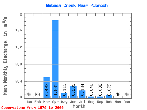
| Statistic | Jan | Feb | Mar | Apr | May | Jun | Jul | Aug | Sep | Oct | Nov | Dec | Annual |
|---|---|---|---|---|---|---|---|---|---|---|---|---|---|
| Mean | 0.49 | 1.83 | 0.12 | 0.29 | 0.18 | 0.04 | 0.04 | 0.08 | |||||
| Standard Deviation | 0.86 | 2.67 | 0.21 | 0.73 | 0.35 | 0.14 | 0.12 | 0.09 | |||||
| Min | 0.00 | 0.00 | 0.00 | 0.00 | 0.00 | 0.00 | 0.00 | 0.00 | |||||
| Max | 3.00 | 10.50 | 0.72 | 2.67 | 1.24 | 0.64 | 0.56 | 0.37 | |||||
| Coefficient of Variation | 1.74 | 1.46 | 1.80 | 2.50 | 1.91 | 3.49 | 3.22 | 1.15 |
 Return to R-Arctic Net Home Page