|
|
|||||||||||||||||
| Point ID: 6599 | Downloads | Plots | Site Data | Code: 9345 |
|
|
|||||||||||||||||
| Download | |
|---|---|
| Site Descriptor Information | Site Time Series Data |
| Link to all available data | |
| View: | Time Series | All |
| Units: | mm |
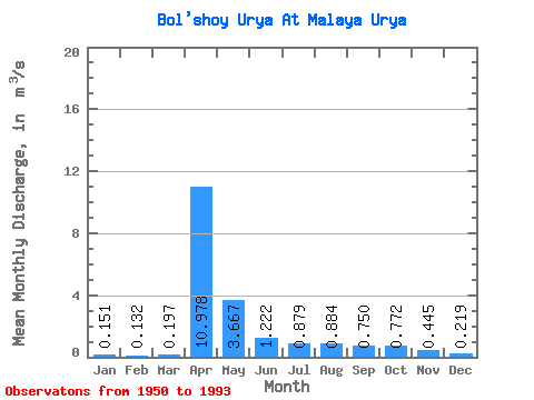
| Statistic | Jan | Feb | Mar | Apr | May | Jun | Jul | Aug | Sep | Oct | Nov | Dec | Annual |
|---|---|---|---|---|---|---|---|---|---|---|---|---|---|
| Mean | 0.15 | 0.13 | 0.20 | 10.98 | 3.67 | 1.22 | 0.88 | 0.88 | 0.75 | 0.77 | 0.45 | 0.22 | 1.69 |
| Standard Deviation | 0.08 | 0.10 | 0.25 | 7.06 | 6.73 | 0.41 | 0.53 | 0.73 | 0.47 | 0.40 | 0.19 | 0.10 | 0.79 |
| Min | 0.03 | 0.02 | 0.02 | 1.33 | 0.38 | 0.43 | 0.27 | 0.26 | 0.32 | 0.27 | 0.14 | 0.08 | 0.61 |
| Max | 0.40 | 0.60 | 1.26 | 31.00 | 44.80 | 2.04 | 2.50 | 3.59 | 2.44 | 1.83 | 1.11 | 0.50 | 4.36 |
| Coefficient of Variation | 0.52 | 0.80 | 1.29 | 0.64 | 1.84 | 0.34 | 0.60 | 0.82 | 0.62 | 0.52 | 0.42 | 0.45 | 0.47 |
 Return to R-Arctic Net Home Page