|
|
|||||||||||||||||
| Point ID: 6573 | Downloads | Plots | Site Data | Code: 9222 |
|
|
|||||||||||||||||
| Download | |
|---|---|
| Site Descriptor Information | Site Time Series Data |
| Link to all available data | |
| View: | Time Series | All |
| Units: | mm |
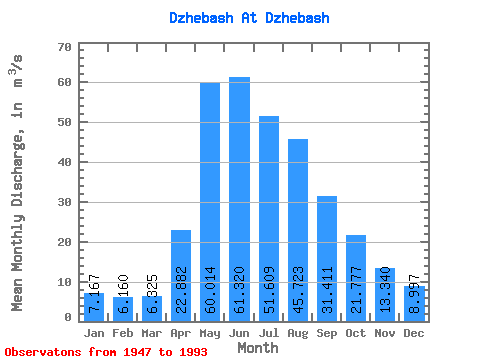
| Statistic | Jan | Feb | Mar | Apr | May | Jun | Jul | Aug | Sep | Oct | Nov | Dec | Annual |
|---|---|---|---|---|---|---|---|---|---|---|---|---|---|
| Mean | 7.17 | 6.16 | 6.33 | 22.88 | 60.01 | 61.32 | 51.61 | 45.72 | 31.41 | 21.78 | 13.34 | 9.00 | 27.84 |
| Standard Deviation | 2.46 | 2.16 | 1.85 | 11.96 | 20.18 | 25.29 | 29.80 | 26.26 | 9.88 | 6.60 | 4.40 | 2.75 | 7.11 |
| Min | 2.59 | 2.10 | 3.23 | 7.72 | 27.20 | 22.50 | 15.90 | 10.60 | 13.80 | 11.90 | 6.19 | 3.58 | 14.78 |
| Max | 16.60 | 14.80 | 13.50 | 54.70 | 114.00 | 130.00 | 163.00 | 115.00 | 54.60 | 37.70 | 26.70 | 18.20 | 45.49 |
| Coefficient of Variation | 0.34 | 0.35 | 0.29 | 0.52 | 0.34 | 0.41 | 0.58 | 0.57 | 0.31 | 0.30 | 0.33 | 0.30 | 0.26 |
 Return to R-Arctic Net Home Page