|
|
|||||||||||||||||
| Point ID: 6540 | Downloads | Plots | Site Data | Other Close Sites | Code: 9030 |
|
|
|||||||||||||||||
| Download | |
|---|---|
| Site Descriptor Information | Site Time Series Data |
| Link to all available data | |
| View: | Time Series | All |
| Units: | mm |
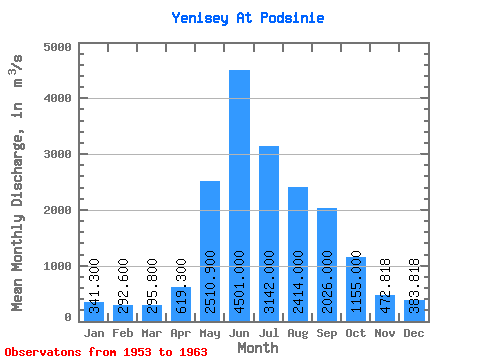
| Statistic | Jan | Feb | Mar | Apr | May | Jun | Jul | Aug | Sep | Oct | Nov | Dec | Annual |
|---|---|---|---|---|---|---|---|---|---|---|---|---|---|
| Mean | 341.30 | 292.60 | 295.80 | 619.30 | 2510.90 | 4501.00 | 3142.00 | 2414.00 | 2026.00 | 1155.00 | 472.82 | 383.82 | 1514.37 |
| Standard Deviation | 42.96 | 39.43 | 40.98 | 285.67 | 861.47 | 634.57 | 767.88 | 460.92 | 248.60 | 76.34 | 82.18 | 49.63 | 172.88 |
| Min | 273.00 | 244.00 | 232.00 | 428.00 | 809.00 | 3640.00 | 1930.00 | 1920.00 | 1630.00 | 1090.00 | 335.00 | 303.00 | 1276.50 |
| Max | 410.00 | 362.00 | 380.00 | 1410.00 | 3570.00 | 5190.00 | 4170.00 | 3170.00 | 2350.00 | 1300.00 | 613.00 | 454.00 | 1819.83 |
| Coefficient of Variation | 0.13 | 0.14 | 0.14 | 0.46 | 0.34 | 0.14 | 0.24 | 0.19 | 0.12 | 0.07 | 0.17 | 0.13 | 0.11 |
| Other Close Sites | ||||||
|---|---|---|---|---|---|---|
| PointID | Latitude | Longitude | Drainage Area | Source | Name | |
| 6570 | "Abakan At Raikov" | 53.58 | 86867 | SHI | 38.00 | |
 Return to R-Arctic Net Home Page