|
|
|||||||||||||||||
| Point ID: 6539 | Downloads | Plots | Site Data | Code: 9022 |
|
|
|||||||||||||||||
| Download | |
|---|---|
| Site Descriptor Information | Site Time Series Data |
| Link to all available data | |
| View: | Time Series | All |
| Units: | mm |
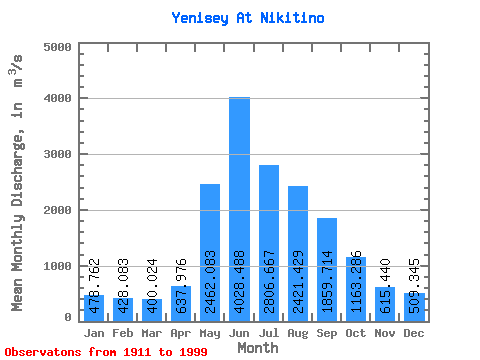
| Statistic | Jan | Feb | Mar | Apr | May | Jun | Jul | Aug | Sep | Oct | Nov | Dec | Annual |
|---|---|---|---|---|---|---|---|---|---|---|---|---|---|
| Mean | 478.76 | 428.08 | 400.02 | 637.98 | 2462.08 | 4028.49 | 2806.67 | 2421.43 | 1859.71 | 1163.29 | 615.44 | 509.35 | 1484.28 |
| Standard Deviation | 372.11 | 362.18 | 366.83 | 379.55 | 802.22 | 1475.31 | 873.33 | 589.55 | 366.58 | 267.42 | 341.03 | 368.88 | 198.05 |
| Min | 182.00 | 136.00 | 113.00 | 170.00 | 764.00 | 843.00 | 1030.00 | 1060.00 | 976.00 | 425.00 | 271.00 | 222.00 | 1122.42 |
| Max | 1700.00 | 1570.00 | 1580.00 | 2100.00 | 4380.00 | 8330.00 | 5170.00 | 4260.00 | 3040.00 | 1930.00 | 1860.00 | 1780.00 | 2063.25 |
| Coefficient of Variation | 0.78 | 0.85 | 0.92 | 0.59 | 0.33 | 0.37 | 0.31 | 0.24 | 0.20 | 0.23 | 0.55 | 0.72 | 0.13 |
 Return to R-Arctic Net Home Page