|
|
|||||||||||||||||
| Point ID: 6537 | Downloads | Plots | Site Data | Other Close Sites | Code: 9002 |
|
|
|||||||||||||||||
| Download | |
|---|---|
| Site Descriptor Information | Site Time Series Data |
| Link to all available data | |
| View: | Time Series | All |
| Units: | mm |
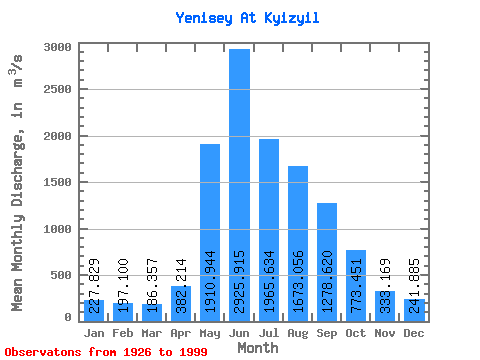
| Statistic | Jan | Feb | Mar | Apr | May | Jun | Jul | Aug | Sep | Oct | Nov | Dec | Annual |
|---|---|---|---|---|---|---|---|---|---|---|---|---|---|
| Mean | 227.83 | 197.10 | 186.36 | 382.21 | 1910.94 | 2925.91 | 1965.63 | 1673.06 | 1278.62 | 773.45 | 333.17 | 241.88 | 1009.52 |
| Standard Deviation | 48.37 | 44.46 | 46.03 | 170.21 | 503.51 | 782.53 | 525.64 | 382.61 | 249.63 | 149.35 | 63.62 | 56.00 | 141.69 |
| Min | 125.00 | 107.00 | 105.00 | 111.00 | 617.00 | 1580.00 | 1090.00 | 917.00 | 733.00 | 516.00 | 218.00 | 90.80 | 739.08 |
| Max | 323.00 | 307.00 | 361.00 | 1040.00 | 2910.00 | 5380.00 | 3520.00 | 2700.00 | 2200.00 | 1360.00 | 526.00 | 366.00 | 1417.92 |
| Coefficient of Variation | 0.21 | 0.23 | 0.25 | 0.45 | 0.26 | 0.27 | 0.27 | 0.23 | 0.20 | 0.19 | 0.19 | 0.23 | 0.14 |
| Other Close Sites | ||||||
|---|---|---|---|---|---|---|
| PointID | Latitude | Longitude | Drainage Area | Source | Name | |
| 6548 | "Bol'shoy Yenisey At Kara-Khak" | 51.88 | 324040 | SHI | 20.00 | |
| 6555 | "Maly Yenisey At Kyzyl" | 51.72 | 327799 | SHI | 2.00 | |
 Return to R-Arctic Net Home Page