|
|
|||||||||||||||||
| Point ID: 6482 | Downloads | Plots | Site Data | Code: 8219 |
|
|
|||||||||||||||||
| Download | |
|---|---|
| Site Descriptor Information | Site Time Series Data |
| Link to all available data | |
| View: | Time Series | All |
| Units: | mm |
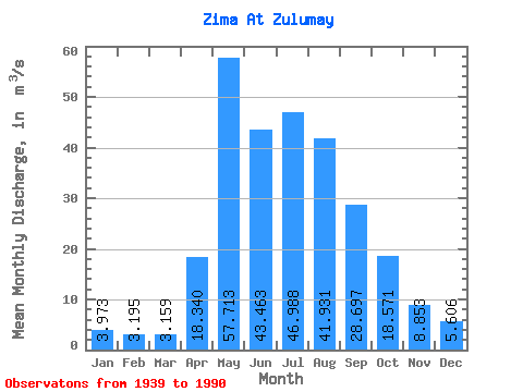
| Statistic | Jan | Feb | Mar | Apr | May | Jun | Jul | Aug | Sep | Oct | Nov | Dec | Annual |
|---|---|---|---|---|---|---|---|---|---|---|---|---|---|
| Mean | 3.97 | 3.19 | 3.16 | 18.34 | 57.71 | 43.46 | 46.99 | 41.93 | 28.70 | 18.57 | 8.85 | 5.61 | 23.89 |
| Standard Deviation | 1.15 | 0.88 | 0.88 | 13.37 | 28.56 | 15.67 | 23.11 | 22.94 | 14.65 | 7.77 | 2.92 | 1.46 | 6.02 |
| Min | 1.67 | 1.01 | 1.39 | 4.22 | 14.80 | 13.50 | 17.60 | 11.00 | 9.44 | 5.53 | 3.12 | 2.38 | 9.51 |
| Max | 6.37 | 5.11 | 5.21 | 74.10 | 127.00 | 85.10 | 122.00 | 114.00 | 83.60 | 43.80 | 15.20 | 8.29 | 36.59 |
| Coefficient of Variation | 0.29 | 0.28 | 0.28 | 0.73 | 0.49 | 0.36 | 0.49 | 0.55 | 0.51 | 0.42 | 0.33 | 0.26 | 0.25 |
 Return to R-Arctic Net Home Page