|
|
|||||||||||||||||
| Point ID: 646 | Downloads | Plots | Site Data | Code: 07BB003 |
|
|
|||||||||||||||||
| Download | |
|---|---|
| Site Descriptor Information | Site Time Series Data |
| Link to all available data | |
| View: | Time Series | All |
| Units: | mm |
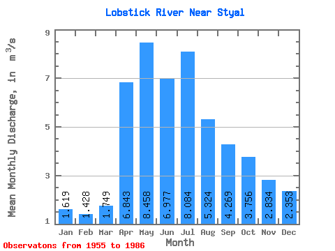
| Statistic | Jan | Feb | Mar | Apr | May | Jun | Jul | Aug | Sep | Oct | Nov | Dec | Annual |
|---|---|---|---|---|---|---|---|---|---|---|---|---|---|
| Mean | 1.62 | 1.43 | 1.75 | 6.84 | 8.46 | 6.98 | 8.08 | 5.32 | 4.27 | 3.76 | 2.83 | 2.35 | 4.52 |
| Standard Deviation | 1.02 | 0.92 | 1.31 | 4.43 | 6.02 | 6.38 | 8.90 | 5.46 | 3.51 | 2.65 | 1.92 | 1.47 | 2.77 |
| Min | 0.00 | 0.00 | 0.00 | 0.94 | 1.61 | 0.47 | 0.62 | 0.27 | 0.16 | 0.21 | 0.20 | 0.01 | 0.89 |
| Max | 3.62 | 3.60 | 6.39 | 22.90 | 30.70 | 27.80 | 36.20 | 21.50 | 13.80 | 9.69 | 6.87 | 4.94 | 12.71 |
| Coefficient of Variation | 0.63 | 0.64 | 0.75 | 0.65 | 0.71 | 0.92 | 1.10 | 1.02 | 0.82 | 0.70 | 0.68 | 0.62 | 0.61 |
 Return to R-Arctic Net Home Page