|
|
|||||||||||||||||
| Point ID: 6456 | Downloads | Plots | Site Data | Code: 8030 |
|
|
|||||||||||||||||
| Download | |
|---|---|
| Site Descriptor Information | Site Time Series Data |
| Link to all available data | |
| View: | Time Series | All |
| Units: | mm |
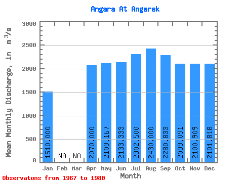
| Statistic | Jan | Feb | Mar | Apr | May | Jun | Jul | Aug | Sep | Oct | Nov | Dec | Annual |
|---|---|---|---|---|---|---|---|---|---|---|---|---|---|
| Mean | 1510.00 | 2070.00 | 2109.17 | 2133.33 | 2302.50 | 2430.00 | 2280.83 | 2099.09 | 2100.91 | 2101.82 | |||
| Standard Deviation | 519.62 | 295.56 | 273.54 | 400.09 | 633.14 | 701.56 | 512.53 | 569.60 | 537.40 | ||||
| Min | 1510.00 | 1770.00 | 1480.00 | 1690.00 | 1830.00 | 1930.00 | 1570.00 | 1490.00 | 1240.00 | 1240.00 | |||
| Max | 1510.00 | 2670.00 | 2560.00 | 2580.00 | 3220.00 | 3840.00 | 3940.00 | 3120.00 | 2900.00 | 2800.00 | |||
| Coefficient of Variation | 0.25 | 0.14 | 0.13 | 0.17 | 0.26 | 0.31 | 0.24 | 0.27 | 0.26 |
 Return to R-Arctic Net Home Page