|
|
|||||||||||||||||
| Point ID: 6446 | Downloads | Plots | Site Data | Code: 7144 |
|
|
|||||||||||||||||
| Download | |
|---|---|
| Site Descriptor Information | Site Time Series Data |
| Link to all available data | |
| View: | Time Series | All |
| Units: | mm |
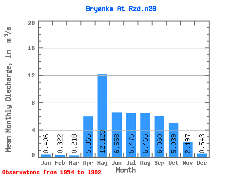
| Statistic | Jan | Feb | Mar | Apr | May | Jun | Jul | Aug | Sep | Oct | Nov | Dec | Annual |
|---|---|---|---|---|---|---|---|---|---|---|---|---|---|
| Mean | 0.41 | 0.32 | 0.22 | 5.96 | 12.12 | 6.56 | 6.47 | 6.46 | 6.06 | 5.04 | 2.20 | 0.54 | 3.73 |
| Standard Deviation | 0.40 | 0.35 | 0.20 | 3.23 | 6.91 | 2.91 | 4.10 | 2.91 | 2.60 | 1.94 | 0.99 | 0.44 | |
| Min | 0.08 | 0.07 | 0.01 | 0.21 | 4.38 | 2.50 | 2.52 | 2.58 | 2.46 | 2.15 | 0.54 | 0.09 | 3.73 |
| Max | 1.00 | 0.57 | 0.57 | 15.80 | 40.30 | 14.90 | 23.70 | 13.20 | 11.70 | 9.20 | 5.16 | 1.60 | 3.73 |
| Coefficient of Variation | 0.98 | 1.08 | 0.94 | 0.54 | 0.57 | 0.44 | 0.63 | 0.45 | 0.43 | 0.39 | 0.45 | 0.81 |
 Return to R-Arctic Net Home Page