|
|
|||||||||||||||||
| Point ID: 6436 | Downloads | Plots | Site Data | Code: 7119 |
|
|
|||||||||||||||||
| Download | |
|---|---|
| Site Descriptor Information | Site Time Series Data |
| Link to all available data | |
| View: | Time Series | All |
| Units: | mm |
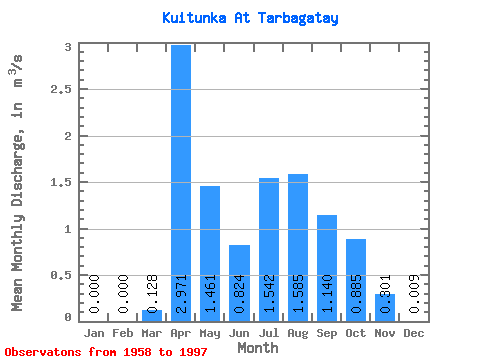
| Statistic | Jan | Feb | Mar | Apr | May | Jun | Jul | Aug | Sep | Oct | Nov | Dec | Annual |
|---|---|---|---|---|---|---|---|---|---|---|---|---|---|
| Mean | 0.00 | 0.00 | 0.13 | 2.97 | 1.46 | 0.82 | 1.54 | 1.58 | 1.14 | 0.89 | 0.30 | 0.01 | 0.90 |
| Standard Deviation | 0.00 | 0.00 | 0.21 | 2.67 | 0.87 | 0.70 | 1.33 | 1.15 | 0.53 | 0.30 | 0.23 | 0.04 | 0.44 |
| Min | 0.00 | 0.00 | 0.00 | 0.45 | 0.33 | 0.13 | 0.19 | 0.27 | 0.35 | 0.36 | 0.03 | 0.00 | 0.29 |
| Max | 0.00 | 0.00 | 0.81 | 16.50 | 3.74 | 3.21 | 7.14 | 5.08 | 2.88 | 1.48 | 0.99 | 0.21 | 2.27 |
| Coefficient of Variation | 1.64 | 0.90 | 0.59 | 0.85 | 0.86 | 0.73 | 0.46 | 0.34 | 0.77 | 4.08 | 0.48 |
 Return to R-Arctic Net Home Page