|
|
|||||||||||||||||
| Point ID: 639 | Downloads | Plots | Site Data | Code: 07AH002 |
|
|
|||||||||||||||||
| Download | |
|---|---|
| Site Descriptor Information | Site Time Series Data |
| Link to all available data | |
| View: | Time Series | All |
| Units: | mm |
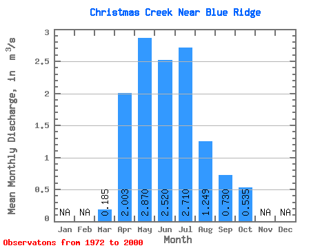
| Statistic | Jan | Feb | Mar | Apr | May | Jun | Jul | Aug | Sep | Oct | Nov | Dec | Annual |
|---|---|---|---|---|---|---|---|---|---|---|---|---|---|
| Mean | 0.18 | 2.00 | 2.87 | 2.52 | 2.71 | 1.25 | 0.73 | 0.54 | |||||
| Standard Deviation | 0.19 | 1.66 | 2.62 | 1.99 | 2.17 | 1.29 | 0.60 | 0.39 | |||||
| Min | 0.01 | 0.30 | 0.33 | 0.12 | 0.06 | 0.05 | 0.02 | 0.03 | |||||
| Max | 1.05 | 6.92 | 11.90 | 7.40 | 8.59 | 5.12 | 2.26 | 1.77 | |||||
| Coefficient of Variation | 1.04 | 0.83 | 0.91 | 0.79 | 0.80 | 1.03 | 0.82 | 0.72 |
 Return to R-Arctic Net Home Page