|
|
|||||||||||||||||
| Point ID: 6344 | Downloads | Plots | Site Data | Code: 3825 |
|
|
|||||||||||||||||
| Download | |
|---|---|
| Site Descriptor Information | Site Time Series Data |
| Link to all available data | |
| View: | Time Series | All |
| Units: | mm |
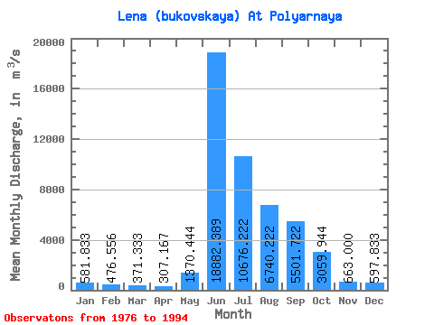
| Statistic | Jan | Feb | Mar | Apr | May | Jun | Jul | Aug | Sep | Oct | Nov | Dec | Annual |
|---|---|---|---|---|---|---|---|---|---|---|---|---|---|
| Mean | 581.83 | 476.56 | 371.33 | 307.17 | 1370.44 | 18882.39 | 10676.22 | 6740.22 | 5501.72 | 3059.94 | 663.00 | 597.83 | 4102.39 |
| Standard Deviation | 193.91 | 163.47 | 127.02 | 93.04 | 1484.65 | 3512.87 | 2462.77 | 1897.09 | 1788.46 | 1254.84 | 201.43 | 206.03 | 722.29 |
| Min | 260.00 | 259.00 | 229.00 | 164.00 | 217.00 | 10958.00 | 6340.00 | 3053.00 | 3245.00 | 300.00 | 352.00 | 275.00 | 2679.92 |
| Max | 954.00 | 866.00 | 700.00 | 481.00 | 6540.00 | 25200.00 | 15400.00 | 11108.00 | 8350.00 | 5280.00 | 1150.00 | 1090.00 | 5315.50 |
| Coefficient of Variation | 0.33 | 0.34 | 0.34 | 0.30 | 1.08 | 0.19 | 0.23 | 0.28 | 0.33 | 0.41 | 0.30 | 0.34 | 0.18 |
 Return to R-Arctic Net Home Page