|
|
|||||||||||||||||
| Point ID: 6321 | Downloads | Plots | Site Data | Code: 3565 |
|
|
|||||||||||||||||
| Download | |
|---|---|
| Site Descriptor Information | Site Time Series Data |
| Link to all available data | |
| View: | Time Series | All |
| Units: | mm |
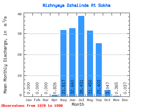
| Statistic | Jan | Feb | Mar | Apr | May | Jun | Jul | Aug | Sep | Oct | Nov | Dec | Annual |
|---|---|---|---|---|---|---|---|---|---|---|---|---|---|
| Mean | 0.00 | 0.00 | 0.00 | 0.83 | 31.82 | 32.66 | 38.43 | 31.45 | 25.40 | 3.05 | 0.36 | 0.04 | 14.12 |
| Standard Deviation | 0.00 | 0.00 | 0.00 | 2.55 | 18.02 | 20.17 | 20.74 | 22.39 | 20.02 | 1.95 | 0.86 | 0.12 | 5.89 |
| Min | 0.00 | 0.00 | 0.00 | 0.00 | 0.22 | 1.85 | 0.17 | 0.20 | 0.23 | 0.05 | 0.00 | 0.00 | 0.23 |
| Max | 0.00 | 0.00 | 0.00 | 9.26 | 56.90 | 66.40 | 74.90 | 82.90 | 77.10 | 6.86 | 2.92 | 0.41 | 22.65 |
| Coefficient of Variation | 3.09 | 0.57 | 0.62 | 0.54 | 0.71 | 0.79 | 0.64 | 2.37 | 3.32 | 0.42 |
 Return to R-Arctic Net Home Page