|
|
|||||||||||||||||
| Point ID: 6310 | Downloads | Plots | Site Data | Code: 3534 |
|
|
|||||||||||||||||
| Download | |
|---|---|
| Site Descriptor Information | Site Time Series Data |
| Link to all available data | |
| View: | Time Series | All |
| Units: | mm |
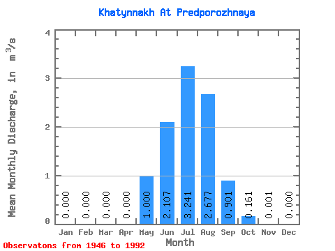
| Statistic | Jan | Feb | Mar | Apr | May | Jun | Jul | Aug | Sep | Oct | Nov | Dec | Annual |
|---|---|---|---|---|---|---|---|---|---|---|---|---|---|
| Mean | 0.00 | 0.00 | 0.00 | 0.00 | 1.00 | 2.11 | 3.24 | 2.68 | 0.90 | 0.16 | 0.00 | 0.00 | 0.86 |
| Standard Deviation | 0.00 | 0.00 | 0.00 | 0.00 | 3.07 | 1.38 | 1.35 | 1.04 | 0.39 | 0.14 | 0.00 | 0.00 | 0.36 |
| Min | 0.00 | 0.00 | 0.00 | 0.00 | 0.01 | 0.31 | 1.50 | 0.84 | 0.04 | 0.00 | 0.00 | 0.00 | 0.51 |
| Max | 0.00 | 0.00 | 0.00 | 0.00 | 14.60 | 6.49 | 6.92 | 4.95 | 1.64 | 0.64 | 0.01 | 0.00 | 2.20 |
| Coefficient of Variation | 3.07 | 0.65 | 0.41 | 0.39 | 0.43 | 0.88 | 3.10 | 0.42 |
 Return to R-Arctic Net Home Page