|
|
|||||||||||||||||
| Point ID: 6307 | Downloads | Plots | Site Data | Code: 3507 |
|
|
|||||||||||||||||
| Download | |
|---|---|
| Site Descriptor Information | Site Time Series Data |
| Link to all available data | |
| View: | Time Series | All |
| Units: | mm |
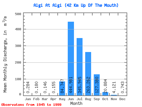
| Statistic | Jan | Feb | Mar | Apr | May | Jun | Jul | Aug | Sep | Oct | Nov | Dec | Annual |
|---|---|---|---|---|---|---|---|---|---|---|---|---|---|
| Mean | 0.28 | 0.18 | 0.15 | 0.15 | 84.75 | 444.98 | 345.94 | 263.26 | 127.38 | 20.88 | 4.12 | 0.74 | 108.57 |
| Standard Deviation | 0.22 | 0.14 | 0.18 | 0.26 | 110.92 | 168.04 | 148.43 | 120.21 | 76.65 | 10.34 | 2.04 | 0.61 | 28.76 |
| Min | 0.02 | 0.00 | 0.00 | 0.00 | 1.68 | 152.00 | 140.00 | 72.90 | 36.10 | 9.94 | 0.46 | 0.06 | 67.49 |
| Max | 1.18 | 0.68 | 1.10 | 1.72 | 615.00 | 908.00 | 1040.00 | 657.00 | 390.00 | 69.50 | 10.70 | 3.34 | 224.53 |
| Coefficient of Variation | 0.78 | 0.80 | 1.25 | 1.65 | 1.31 | 0.38 | 0.43 | 0.46 | 0.60 | 0.49 | 0.49 | 0.82 | 0.27 |
 Return to R-Arctic Net Home Page