|
|
|||||||||||||||||
| Point ID: 630 | Downloads | Plots | Site Data | Code: 07AG001 |
|
|
|||||||||||||||||
| Download | |
|---|---|
| Site Descriptor Information | Site Time Series Data |
| Link to all available data | |
| View: | Time Series | All |
| Units: | mm |
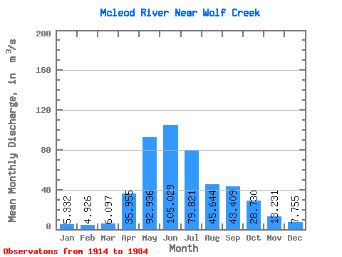
| Statistic | Jan | Feb | Mar | Apr | May | Jun | Jul | Aug | Sep | Oct | Nov | Dec | Annual |
|---|---|---|---|---|---|---|---|---|---|---|---|---|---|
| Mean | 5.33 | 4.93 | 6.10 | 35.95 | 92.94 | 105.03 | 79.82 | 45.64 | 43.41 | 28.73 | 13.23 | 7.75 | 39.48 |
| Standard Deviation | 2.45 | 2.38 | 3.34 | 19.76 | 48.53 | 69.94 | 62.86 | 34.99 | 40.26 | 18.90 | 6.30 | 3.39 | 14.37 |
| Min | 1.11 | 0.23 | 0.26 | 9.52 | 19.50 | 30.80 | 17.90 | 13.50 | 9.37 | 8.81 | 4.60 | 2.10 | 18.90 |
| Max | 12.70 | 10.90 | 17.10 | 78.70 | 208.00 | 400.00 | 275.00 | 176.00 | 199.00 | 105.00 | 31.40 | 15.30 | 71.84 |
| Coefficient of Variation | 0.46 | 0.48 | 0.55 | 0.55 | 0.52 | 0.67 | 0.79 | 0.77 | 0.93 | 0.66 | 0.48 | 0.44 | 0.36 |
 Return to R-Arctic Net Home Page