|
|
|||||||||||||||||
| Point ID: 63 | Downloads | Plots | Site Data | Code: 05AC013 |
|
|
|||||||||||||||||
| Download | |
|---|---|
| Site Descriptor Information | Site Time Series Data |
| Link to all available data | |
| View: | Time Series | All |
| Units: | mm |
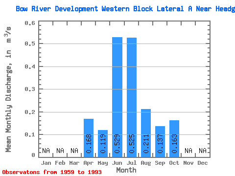
| Statistic | Jan | Feb | Mar | Apr | May | Jun | Jul | Aug | Sep | Oct | Nov | Dec | Annual |
|---|---|---|---|---|---|---|---|---|---|---|---|---|---|
| Mean | 0.17 | 0.12 | 0.53 | 0.53 | 0.21 | 0.14 | 0.16 | ||||||
| Standard Deviation | 0.19 | 0.31 | 0.36 | 0.11 | 0.10 | 0.13 | |||||||
| Min | 0.17 | 0.00 | 0.00 | 0.07 | 0.03 | 0.00 | 0.00 | ||||||
| Max | 0.17 | 0.83 | 1.02 | 1.32 | 0.46 | 0.38 | 0.39 | ||||||
| Coefficient of Variation | 1.57 | 0.59 | 0.68 | 0.51 | 0.70 | 0.79 |
 Return to R-Arctic Net Home Page