|
|
|||||||||||||||||
| Point ID: 6296 | Downloads | Plots | Site Data | Code: 3443 |
|
|
|||||||||||||||||
| Download | |
|---|---|
| Site Descriptor Information | Site Time Series Data |
| Link to all available data | |
| View: | Time Series | All |
| Units: | mm |
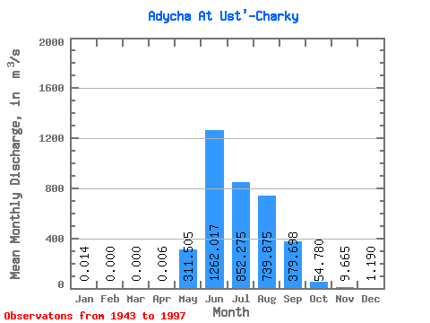
| Statistic | Jan | Feb | Mar | Apr | May | Jun | Jul | Aug | Sep | Oct | Nov | Dec | Annual |
|---|---|---|---|---|---|---|---|---|---|---|---|---|---|
| Mean | 0.01 | 0.00 | 0.00 | 0.01 | 311.50 | 1262.02 | 852.27 | 739.88 | 379.70 | 54.78 | 9.66 | 1.19 | 300.92 |
| Standard Deviation | 0.05 | 0.00 | 0.00 | 0.03 | 190.02 | 538.42 | 308.37 | 341.26 | 224.89 | 34.31 | 4.21 | 1.15 | 81.67 |
| Min | 0.00 | 0.00 | 0.00 | 0.00 | 15.80 | 72.70 | 436.00 | 176.00 | 79.90 | 16.10 | 0.38 | 0.00 | 74.70 |
| Max | 0.24 | 0.00 | 0.00 | 0.13 | 980.00 | 2540.00 | 1800.00 | 1770.00 | 961.00 | 195.00 | 20.10 | 6.49 | 528.82 |
| Coefficient of Variation | 3.73 | 4.47 | 0.61 | 0.43 | 0.36 | 0.46 | 0.59 | 0.63 | 0.43 | 0.97 | 0.27 |
 Return to R-Arctic Net Home Page