|
|
|||||||||||||||||
| Point ID: 628 | Downloads | Plots | Site Data | Code: 07AF909 |
|
|
|||||||||||||||||
| Download | |
|---|---|
| Site Descriptor Information | Site Time Series Data |
| Link to all available data | |
| View: | Time Series | All |
| Units: | mm |
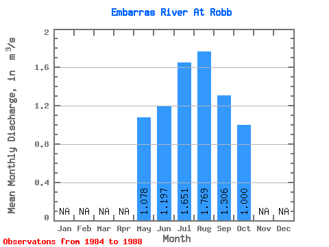
| Statistic | Jan | Feb | Mar | Apr | May | Jun | Jul | Aug | Sep | Oct | Nov | Dec | Annual |
|---|---|---|---|---|---|---|---|---|---|---|---|---|---|
| Mean | 1.08 | 1.20 | 1.65 | 1.77 | 1.31 | 1.00 | |||||||
| Standard Deviation | 0.65 | 0.48 | 2.31 | 1.75 | 0.82 | 0.60 | |||||||
| Min | 0.52 | 0.40 | 0.49 | 0.31 | 0.45 | 0.35 | |||||||
| Max | 2.13 | 1.59 | 5.78 | 4.68 | 2.62 | 1.88 | |||||||
| Coefficient of Variation | 0.60 | 0.40 | 1.40 | 0.99 | 0.63 | 0.60 |
 Return to R-Arctic Net Home Page