|
|
|||||||||||||||||
| Point ID: 626 | Downloads | Plots | Site Data | Code: 07AF906 |
|
|
|||||||||||||||||
| Download | |
|---|---|
| Site Descriptor Information | Site Time Series Data |
| Link to all available data | |
| View: | Time Series | All |
| Units: | mm |
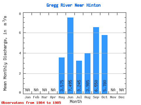
| Statistic | Jan | Feb | Mar | Apr | May | Jun | Jul | Aug | Sep | Oct | Nov | Dec | Annual |
|---|---|---|---|---|---|---|---|---|---|---|---|---|---|
| Mean | 3.58 | 7.50 | 3.25 | 3.98 | 6.55 | 5.78 | |||||||
| Standard Deviation | 0.33 | 1.70 | 0.77 | 3.95 | 2.46 | 3.01 | |||||||
| Min | 3.34 | 6.29 | 2.70 | 1.19 | 4.81 | 3.65 | |||||||
| Max | 3.81 | 8.70 | 3.79 | 6.78 | 8.29 | 7.91 | |||||||
| Coefficient of Variation | 0.09 | 0.23 | 0.24 | 0.99 | 0.38 | 0.52 |
 Return to R-Arctic Net Home Page