|
|
|||||||||||||||||
| Point ID: 6257 | Downloads | Plots | Site Data | Code: 3293 |
|
|
|||||||||||||||||
| Download | |
|---|---|
| Site Descriptor Information | Site Time Series Data |
| Link to all available data | |
| View: | Time Series | All |
| Units: | mm |
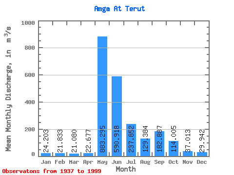
| Statistic | Jan | Feb | Mar | Apr | May | Jun | Jul | Aug | Sep | Oct | Nov | Dec | Annual |
|---|---|---|---|---|---|---|---|---|---|---|---|---|---|
| Mean | 24.20 | 21.83 | 21.08 | 22.68 | 883.29 | 590.92 | 237.85 | 129.38 | 182.89 | 114.00 | 37.01 | 29.94 | 191.42 |
| Standard Deviation | 10.95 | 10.03 | 9.92 | 10.36 | 412.82 | 268.81 | 183.59 | 83.53 | 155.96 | 81.96 | 21.67 | 14.35 | 61.19 |
| Min | 5.08 | 4.77 | 3.55 | 6.45 | 204.00 | 184.00 | 60.00 | 44.70 | -189.00 | 25.90 | 11.20 | 7.37 | 63.58 |
| Max | 66.20 | 60.90 | 55.60 | 68.20 | 1860.00 | 1190.00 | 1140.00 | 381.00 | 579.00 | 488.00 | 121.00 | 80.70 | 386.73 |
| Coefficient of Variation | 0.45 | 0.46 | 0.47 | 0.46 | 0.47 | 0.46 | 0.77 | 0.65 | 0.85 | 0.72 | 0.58 | 0.48 | 0.32 |
 Return to R-Arctic Net Home Page