|
|
|||||||||||||||||
| Point ID: 6246 | Downloads | Plots | Site Data | Code: 3266 |
|
|
|||||||||||||||||
| Download | |
|---|---|
| Site Descriptor Information | Site Time Series Data |
| Link to all available data | |
| View: | Time Series | All |
| Units: | mm |
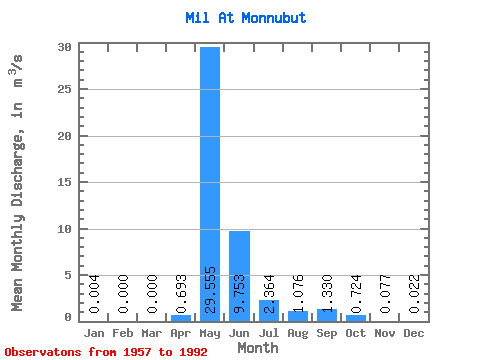
| Statistic | Jan | Feb | Mar | Apr | May | Jun | Jul | Aug | Sep | Oct | Nov | Dec | Annual |
|---|---|---|---|---|---|---|---|---|---|---|---|---|---|
| Mean | 0.00 | 0.00 | 0.00 | 0.69 | 29.55 | 9.75 | 2.36 | 1.08 | 1.33 | 0.72 | 0.08 | 0.02 | 3.68 |
| Standard Deviation | 0.01 | 0.00 | 0.00 | 1.93 | 25.75 | 8.53 | 3.31 | 1.22 | 1.46 | 0.83 | 0.06 | 0.03 | 2.63 |
| Min | 0.00 | 0.00 | 0.00 | 0.00 | 0.11 | 0.88 | 0.26 | 0.10 | 0.05 | 0.01 | 0.00 | 0.00 | 0.18 |
| Max | 0.04 | 0.00 | 0.00 | 9.20 | 78.80 | 34.40 | 16.10 | 4.68 | 5.61 | 3.42 | 0.26 | 0.10 | 9.09 |
| Coefficient of Variation | 2.54 | 2.79 | 0.87 | 0.88 | 1.40 | 1.14 | 1.09 | 1.14 | 0.81 | 1.31 | 0.71 |
 Return to R-Arctic Net Home Page